Sunday, December 25, 2011

Gray Shrubs


Weather: Snow early Monday and again Thursday; warm afternoons defrost top of ground into slippery layer over frozen base that refreezes and heaves at night; 9:43 hours of daylight today.

What’s still green: Juniper and other evergreens, rose stems, hollyhock, winecup, cheese mallow, vinca, sea pink, coral beardtongue, gypsum phacelia, snakeweed, strap-leaf aster, cheat grass.

What’s red:
Cholla; branches on coyote willow, apples, apricots, spirea and raspberry; leaves on red hot poker, coral bells, small-leafed soapwort, pink evening primrose.

What’s blue or gray: Piñon; leaves on four-winged saltbush, snow-in-summer, pinks, yellow alyssum, golden hairy and purple asters.

What’s yellow-green/yellow-brown: Arborvitae, branches on weeping willow.

What’s blooming inside: Aptenia, asparagus fern, zonal geranium, Christmas cactus.

Animal sightings: Small birds, rabbit tracks.

Weekly update: Blame it on Zane Grey.

If James Fenimore Cooper defined the near west where Indians moved through primeval forests, Grey created our image of the far west where men ride horses through fields of sage.


When people see the gray shrubs growing along my drive, they compliment me on my sagebrush. When I demur, they give me that look the cognoscenti reserve for the feeble minded.

The logic is inexorable:
Sagebrush dominates many parts of the far west.
Sagebrush is gray.
These shrubs are gray.
This is the west.
Ergo, these shrubs are sagebrush.

There is no room for winterfat in such a world.

Last week I took a reality check. I drove up route 68 towards Taos through volcanic boulders and uplifted rocks. When you reach the top, a broad plateau opens, covered with sagebrush as far as you can see.


On the way back, I looked for the boundary between winterfat and sagebrush. It’s somewhere around Rinconada.

Above that point, sagebrush grows on volcanic rises on the western side of the river, and in crevices to the east. Between there and the Dixon turnoff, you see a few patches of winterfat. Below that point, it’s mainly chamisa and salt bush. Between Velarde and Española cholla grows with grasses on the eastern open land.


You don’t see much winterfat again until you take route 30 toward Los Alamos and pass through unsettled land between Santa Clara and San Ildefonso. The reason is probably quite simple. Unlike sagebrush, winterfat is quite palatable and doesn’t recover when overgrazed by sheep.

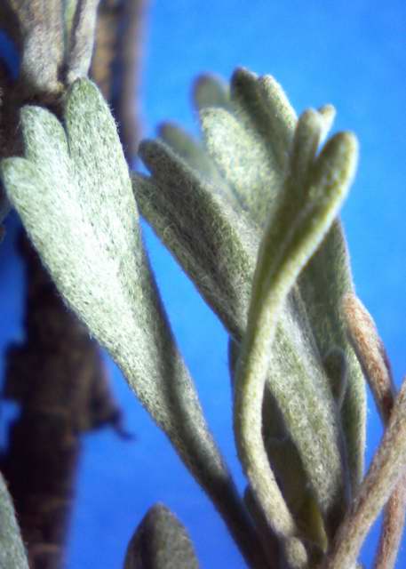
The two shrubs aren’t easy to tell apart at 60 miles an hour. If you stop, sagebrush has three-toothed leaves that persist into this season. Winterfat has long narrow leaves that first turned pink and now are tan, if they haven’t fallen completely. In their place are small, partly opened clusters of next year’s leaves. Both get their color from white hairs.

If you make the mistake of walking too close to either, your clothes get covered with debris that’s difficult to pick off. Sagebrush fragments smell; winterfat’s don’t.


If you happen to drive by either when they’re blooming, you can recognize the sagebrush by its yellow aura. Winterfat flowers are nearly invisible. What you see is light reflected through the fluffy white seed tails.

Artemisia tridentata is a composite with perfect flowers. Eurotia lanata is a chenopod with separate male and female florets.


This time of year, what distinguishes them from a distance are the floral remains. The receptacles of sagebrush are dirty brown in narrow plumes, while the male flowers of winterfat are titanium bumps on bare stems. The larger, redder brown heads you see along the road belong to salt bush. The lighter, more golden ones are chamisa.

If the bracts of sagebrush have fallen off, then its bare stems look no different than the tips of winterfat where the seedless male flowers are concentrated.


Sometimes though you can distinguish them by their habit. As winterfat ages, it sends new stems with shaving brush tops which force the existing stems to spread. Sage, at least the tridentata subspecies, has a main stalk and manages to stay erect, even when decrepit.


I suppose it’s soil that determines which you see. In this area, winterfat grows on recent Quaternary alluvial soils near the river, while the few sagebrush plants I’ve seen were near older, Tertiary badlands. On the road between Rinconada and Taos, the shrubs grow in disintegrating lava fields. The first tend to be finer grained than the second.

In the end, you may only know one from the other by remembering where you are, a local version of “If this is Tuesday, it must be Brussels.” However, if you really must visit the world defined by Zane Grey, there’s a small plateau in the climb north where sagebrush fills a narrow ledge and horses are available to rent. Sniff your pant legs when you leave.


Photographs:
1. Gray shrub and grassland on route 84 north of Abiquiú dam. I didn’t get out to look. It has a single stem but no sign of flowers on 3 September 2011.

2. Winterfat volunteers along my drive, 15 June 2011.


3. Sagebrush, tridentata subspecies, on Taos plateau with river gorge in middle distance, and sagebrush beyond, 11 December 2011.

4. Winterfat along the road north of the Dixon exit on route 68, 11 December 2011.

5. Pinkened winterfat leaves with white seed tails, from a shrub in my drive, 6 December 2011.

6. Sagebrush flower receptacle from Taos plateau, 11 December 2011.

7. Left, sagebrush stem tip with remains of flower receptacles from Taos plateau; right, winterfat stem tip with remains of male flowers and new leaf buds from Embudo valley, 11 December 2011.


8. Winterfat sprawling on Santa Clara land, route 30, 11 December 2011.

9. Erect, but dead sagebrush and shrubs with tan receptacles north of Pilar on route 68; light headed chamisa in the center and more sagebrush and juniper on the back ledge, 11 December 2011.

10. New winterfat leaf cluster with last season’s leaves, from my drive, 6 December 2011.

11. Sagebrush leaves, tridentata subspecies, from somewhere along route 68, 11 December 2011.

Sunday, December 18, 2011

Sagebrush


Weather: Monday’s snow landed on the snow still here from a week ago; Tuesday’s rain didn’t wash everything away; temperatures have been too cold since to melt much; 9:43 hours of daylight today.

What’s still green: Juniper and other evergreens, rose stems, hollyhock, winecup, vinca, sea pink, coral beardtongue, gypsum phacelia, snakeweed, strap-leaf aster leaves.

Still green plants, like gypsum phacelia, seem to peak through snow first, perhaps because they generate heat from below that adds to effects of the sun above.

What’s red/turning red: Cholla; branches on coyote willow, apples, apricots, spirea and raspberry; leaves on red hot poker, coral bells, small-leaved soapwort, pink evening primrose.

What’s blue or gray: Piñon; leaves on four-winged saltbush, snow-in-summer, pinks, yellow alyssum, golden hairy and purple asters.

What’s yellow-green: Branches on weeping willow; arborvitae beginning to bronze.

What’s blooming inside: Aptenia, asparagus fern, zonal geranium; buds on Christmas cactus.

Animal sightings: Small birds.

Weekly update: The day before Thanksgiving, I wandered out toward one of the badland formations for a closer look at junipers I’d seen for years from my back porch. I found them growing in an allée bordering a wide stretch of ground bared by flowing water.

Having gotten that far, I thought why not start up the water path towards the sedimentary cliffs themselves. Bunch grasses were dark and dormant, but Gypsum phacelia was green everywhere.


Then I saw something I’d never seen before in this area, a very low sagebrush. Soon after, the alkaline loving phacelia disappeared, and more sagebrushes sprawled about, exploiting, if not directing, the movement of water.

These plants had the shorter, wider three-lobed leaves and branching habit of the wyomingensis subspecies of Artemisia tridentata found in this state in Rio Arriba and Taos counties.

The other big sagebrush subspecies, tridentata, with longer, narrower three-toothed leaves and a central trunk, is also found in Rio Arriba and Taos counties, but also in San Juan county to the west. It doesn’t grow in Santa Fe or Los Alamos counties, but in Sandoval and McKinley to the west. It isn’t around Albuquerque, but in Valencia and Torrance counties to the south.

While I associate sagebrushes with the Taos plateau, Frederic Clements warns their dominance is recent, the likely consequence of overgrazing the original grasslands in the late nineteenth century.

Like the badlands, where remains of ancient horses and camels have been found, the Artemisia genus appeared sometime in the Miocene when grasses were emerging. Clements believes the two have had an antiphonal relationship since, with grasses appearing in wet periods and sagebrushes dominating when the climate dried.

In historic times, he thinks the range of sagebrush was limited to desert areas where its roots penetrated deeper than those of the more common grasses. Most of the native groups who used the plant, mainly for medicine, live in the dryer northwestern part of the state, the Hopi, Zuñi, Navajo and Apache.

Tewa speakers used the dark woody branches as fuel when nothing better was available, say “on the journey from San Juan to Taos.” They used the leaves, which they could have brought back, to treat indigestion, flatulence, coughs and congestion.


The gray leaves have a bitter taste which discourages many animals from eating them, except during famine times. The nitrogen containing monoterpene oils that make them medicinally useful attack the digesting bacteria in animals’ stomachs. When sheep or cattle were abusing a stand of grass, sagebrush had a competitive advantage.

About the only wild animal who can digest the composite is the pronghorn, whose ancestors emerged in the post-Miocene when “the lower valleys appear to have been primarily clothed in spruce parklands, marshy meadows, or sagebrush (Artemisia) steppe with subalpine conifers and shrubs dominating the coarser sites.” The modern animal evolved when tree and grass savannas were alternating with shrub steppes during the warm periods between glacial advances.

William Dick-Peddie suggests the mechanics of domination are those of erosion. When grasses are eaten to stubs, water flows over the land, rather than into it. Juniper sprouts in depressions where water collects, while sagebrush nestles in the slightly elevated spots between.


I have no idea from whence came the seeds of the shrubs I saw or if they had taking advantage of the past season’s drought. Seed can last at least nine years under the right conditions, but it first has to be in the area. I haven’t ventured past the cliffs yet to see what grows beyond, so I don’t know if there’s some indigenous source or if the tiny brown seeds were tracked in by hikers or ATV tires.

I waited twenty years to visit the junipers and badlands. No matter how intense my curiosity now, I have no choice but to wait until the snow clears enough so I can see where I’m walking.

Notes:Brown, David E. “An Evolutionary History of Pronghorn Habitat and Its Effect on Taxonomic Differentiation,” Pronghorn Workshop, 2006.

Clements, Frederic E. Dynamics of Vegetation, collected papers edited by B. W. Allred and Edith S. Clements, 1949.

Dick-Peddie, William A. New Mexico Vegetation, 1993.

Moerman, Dan. Native American Ethnobotany, 1998, summarizes data from a number of ethnographies.

Robbins, William Wilfred, John Peabody Harrington, and Barbara Friere-Marreco. Ethnobotany of the Tewa Indians, 1916.

Tilley, Derek J., Dan Ogle, Loren St. John, and Brock Benson. “Big Sagebrush,” USDA Natural Resources Conservation Service plant guide.

United States Department of Agriculture, Natural Resources Conservation Service. New Mexico county distribution maps for Artemisia tridentata subspecies.

Photographs: All were taken near the local badlands, 23 November 2011. Gypsum phacelia in lower left hand corner of second picture.

Sunday, December 11, 2011

Four-Winged Saltbush


Weather: Three inches of snow fell Monday with zero morning temperatures Tuesday.

Thursday snow from the south-facing roof melted, then froze again when it landed on the rose leaves below.

Afternoon temperatures didn’t rise above freezing until Friday. Snow stayed on ground where it could sink rather than rise with evaporative melting. The snow also insulated plants from the cold night temperatures. The only places bare yesterday afternoon were south facing ones where it’s always been difficult to get perennials or shrubs to grow.

9:49 hours of daylight today.

What’s still green: Juniper, arborvitae and other evergreens, hollyhock, winecup, vinca, coral beardtongue, clover; new leaf buds visible on Bradford pear.

What’s red/turning red: Cholla; young branches of tamarix, apples and raspberry; leaves on roses, red hot poker, coral bells, pink evening primrose; raspberries and privet dropped leaves.

What’s blue or grey: Piñon; leaves on four-winged saltbush, snow-in-summer, pinks, yellow alyssum, winterfat, golden hairy and purple asters; remaining leaves fell on snow from my neighbor’s Russian olive.

What’s yellow-green: Branches on weeping willow.

What’s blooming inside: Aptenia, asparagus fern, zonal geranium; buds on Christmas cactus.

Animal sightings: Small birds in the shrubs; geese were flying south along the river Monday; rabbits were out in the snow Tuesday in the far arroyo.


Weekly update: Four-winged saltbushes grow nearly everywhere in the arid west from central México, where they evolved, up into Alberta. In the immediate area, they don’t grow on the prairies where they would compete with bunch grasses, but instead prefer disturbed, moister lands near arroyos and wash outs.

I don’t know if this is a consequence of sheep eating the shrubs into extinction, so only relic stands remain, or if they never were particularly plentiful in this area. The closest native group to recognize them in historic times was the Jemez, who used the grey leaves to treat ant bites and revive the faint. Farther south the Isleta used the dark wood for poisonous arrowheads.

The shrub’s primary New Mexico homeland, juniper savannah, is found along feeders to the Rio Grande, including the Rio Puerco from the west. Otherwise, William Dick-Peddie suggests the shrub grows where deep sand and water coexist, like areas along the Rio Chama north of Española, the shoulders of the Rio Grande south of Albuquerque where the Isleta live, and the Great Basin desert scrub lands of the Rio San Juan in the northwest.

Before ranchers arrived, rabbits were probably the principal feeders on Atriplex canescens. They also use the shrubs for shelter and water. The Zuñi, who held ceremonial rabbit hunts, tied prayer plumes to the twigs during winter solstice ceremonies to ensure the animals would be available in large numbers.

House finches lived in my bushes this summer after they abandoned their attempts to live on the porch rafters. In other parts of the country quail, grouse and gray partridges eat the fruits, while pheasant nest under shrubs that provide shelter from winter.

Ranchers soon learned the chenopod’s protein, fat and carbohydrate levels match those of alfalfa for sheep, especially in winter when the leaves are high in carotene and other vegetation sparse. There’s enough evidence that in this immediate area someone ran sheep, because overgrazed sections haven’t recovered.


Not only are there large sections of winterfat uphill from my house and on the river side of the ranch road, but there’s a section of winterfat as you continue down that dirt road toward the ranch. Beyond the fence, pueblo land is still grass and juniper. Salt bushes grow along the boundary, some with rust-colored heads, others simple humps of loden.

You see single saltbushes along the road near the village and can spot scattered ones back a bit, here and there. However, the species has both male and female plants. There must be enough of each sex within wind reach of each other for a copse to develop. Males seem to be more common than females.

The largest stand is in a wash that lies on the other side of a road from land used by the rancher. Until the neighbor’s dogs chased them out, that’s where rabbits lived. The cottontails moved under the sheds and debris in my uphill neighbor’s fenced yard from whence they venture into the wash when the dogs are confined.


The other place the shrubs grow in large numbers is along the top of the far arroyo bank where any animal that tried to eat them would probably plunge to its death when its weight collapsed the bank under it.


The saltbush, at least for a while, would survive with its roots exposed. Indeed, one this summer that lost its footings in the August flood, put out new leaves along the bare root by the end of October.


I often wonder how anything can survive such marginal environments. The shrub itself lets rain or snow through its dense, crisscrossing branches, then hides it from the sun. The snow makes obvious that seeds take root where there’s enough hidden water to support them.


Life on the ridges remains precarious. Nothing can live forever with compromised roots. Sooner or later more of the bank erodes and skeletons, dead and alive, tumble to the arroyo floor.


But, more than dead branches fall. Seeds drift down, take root and grow quickly. A colony has developed at the south end of the far arroyo’s steep bank which is where the rabbits have been heading since Monday’s snow.


Notes: The roots and soil preferences of four winged saltbush were discussed in the entry for 11 February 2007.

Dick-Peddie, William A. New Mexico Vegetation, 1993.

Howard, Janet L. “Atriplex canescens,” 2003, in United States Forest Service, Fire Effects Information System.

Moerman, Dan. Native American Ethnobotany, 1998, summarizes data from a number of ethnographies, including Sarah Louise Cook, The Ethnobotany of Jemez Indians, 1930, and Volney H. Jones, The Ethnobotany of the Isleta Indians, 1931.

Stevenson, Matilda Coxe. Ethnobotany of the Zuni Indians, 1915.

Photographs: Four-winged saltbushes growing
1. on the prairie, 7 August 2011.
2. in the near wash with both males and females; winterfat in front, 2 October 2011.
3. between winterfat and pueblo land on ranch road with males and females, 7 November 2011.
4. in the near wash with rabbit tracks, 8 December 2011.
5. along the top of the right bank of the far arroyo, 12 June 2011.
6. with an exposed root along low bank of the far arroyo, 30 October 2011.
7. along the right bank of the far arroyo, 6 December 2011.
8. with dead plants washed into the far arroyo, 30 May 2011.
9. at base of right bank in far arroyo, with rabbit tracks, 8 December 2011.
10. with exposed roots and few viable branches trapping water along the top of the right bank, 11 September 2011.

Sunday, December 04, 2011

The River


Weather: Snow lingers in north and west facing beds, and in low places between bunch grasses; drip lines collecting water that freezes at night; 9:55 hours of daylight today.

What’s still green: Juniper, arborvitae and other evergreens, roses, prickly pear, yuccas, grape hyacinth, oriental poppy, coral beard tongue, Jupiter’s beard, snapdragons, large leaved soapwort, ladybells, hollyhock, winecup, cheese, sweet pea, alfalfa, clovers, bindweed, yellow evening primrose, vinca, gypsum phacelia, anthemis, chrysanthemum, coreopsis, strapleaf and purple asters, June, cheat, pampas and other grasses.

What’s red/turning red: Cholla; young branches of apples and tamarix; leaves on raspberry, privet, Japanese honeysuckle, red hot poker, pinks, small leaved soapwort, Husker’s and purple beard tongue, coral bells, pink evening primrose, alfilerillo.

What’s blue or grey: Piñon; leaves on four-winged saltbush, California poppy, loco, catmints, snow-in-summer, yellow alyssum, winterfat, creamtips, hairy golden and heath asters.

What’s yellow-green/turning yellow: Branches on weeping willow; leaves on Apache plume, rugosa rose, sea pink, golden spur columbine, snakeweed.

What’s blooming inside: Aptenia, asparagus fern, zonal geranium.

Animal sightings: Small birds.

Weekly update: It rained the day after Thanksgiving. By noon the ground was wet, the air misty, the sky gray. It seemed the perfect time to walk towards the Rio Grande.

I’ve found ways to get to it in town, but I’ve been here more than 20 years and never actually seen the river near my house.

As soon as I skirted the new bridge and old ford in the far arroyo, the terrain changed into a bulldozed mud flat with cottonwoods marking the perimeter. I’d known there was a sharp drop behind the houses on the other side of the bridge, but I hadn’t realized the nearness of that bank.


A levee had been built on the right side. The arroyo at times was contained in a small channel, but wet open land spread on the other side. I suspect, before they started regulating the river’s flow, this was its flood plain.


I’m not sure why the levee was built or if it’s still maintained. It would have been a more effective barrier for modern homes on the other side of the channel. Perhaps it provided the arroyo with an exit path through water flowing back from the river, and thus prevented problems upstream.

I suppose this once was bosque. The cottonwoods were widely spaced, but the ground was littered with fragments of dead branches. Someone had cleared the area, and only grass had come back. I don’t know if that’s because trees had died, people were hunting fire wood, or they feared fire and vermin.


Russian thistles grew on the levee. There was also one band of three foot plants in the mud plain, but none had invaded the wetter area colonized by grasses. In the distance, I first saw the bare red stems of willows. The cottonwoods always looked denser in the distance than they were when I got to them.


I passed a row of what could have been young chamisa. The sodden brown heads looked familiar, but the stems weren’t particularly woody. It’s possible that dead wood littering the ground was from large shrubs that had been cleared out and all I saw was regrowth. The rings of wood were about the right size.


The river was closer than I thought, just over a mile from my house. The willows I had been heading for were on the other side of the water.


Where I came out the bank was clear. A few Russian olives, grass. On both sides of me, though, vegetation closed in. It wasn’t wild or like it was before the Spanish or the Anglos, but it did sport a faint rainbow toward town. Downstream, clouds still hung over the Jemez.


Photographs: All pictures taken 25 November 2011.

Sunday, November 27, 2011

Juniper


Weather: Except for Thanksgiving, morning temperatures warmer than last week until this morning, which is the coldest so far; rain Friday; 10:06 hours of daylight today.

What’s blooming: Pansy next to a fence, under snapdragons and low to the ground.

Seed catalogs, that used to come between Christmas and New Years, started arriving before Thanksgiving.

What’s still green: Juniper, arborvitae and other evergreens, roses, prickly pear, yuccas, grape hyacinth, red hot pokers, oriental poppy, golden-spur columbine, coral beard tongue, Jupiter’s beard, snapdragons, large leaved soapwort, ladybells, winecup, cheese, sweet pea, alfalfa, clovers, bindweed, yellow evening primrose, vinca, gypsum phacelia, anthemis, chrysanthemum, coreopsis, strapleaf and purple asters, June, cheat and other grasses, gray mushrooms.

With cold, leaf stems on hollyhocks have broken, but the leaves are still green. Friday’s rain took down most of the leaves still on my trees.

What’s red/turning red: Cholla, leaves on raspberry, privet, Japanese honeysuckle, pinks, small leaved soapwort, Husker’s and purple beard tongue, coral bells, pink evening primrose, alfilerillo.

What’s blue or grey: Piñon, leaves on four-winged saltbush, California poppy, loco, catmints, snow-in-summer, yellow alyssum, winterfat, creamtips, hairy golden and heath asters.

What’s yellow-green/turning yellow: Leaves on weeping willow, Apache plume, rugosa rose, sea pink, snakeweed.

What’s blooming inside: Aptenia, asparagus fern, zonal geranium.

Animal sightings: Small birds.

Something that looked like a chipmunk dove for its hole by the near arroyo, then look back out. Was small, with brown fur and not much of a tail.

Weekly update: One-seeded juniper may be the indicative plant for this region, but you won’t find it just anywhere. Few grow in the nearby prairie. Instead, you see the dark green forms climbing distant hills.

I’ve often wondered why.

Hart Merriam, who first identified the piñon-juniper zone, thought temperature was the determining factor in the southwest, that it decreased with elevation while precipitation increased. His brother-in-law, Vernon Bailey, suggested the major factor separating areas within the piñon-juniper province in New Mexico was humidity. A LANL team headed by Kevin Reid theorized it was soil moisture on the Pajarito Plateau.


I finally got a clue a couple weeks ago when I climbed to the top of a small hill that was grassy at the bottom and brown on top. I discovered the reason is the base was simple alluvial soil and the top was covered with layers of thin conglomerate. At the very top, in the middle of the biggest rocks, where water was most likely to run away quickly, juniper was growing.


Rocks.

I’ve spent the past two weeks rather rudely looking under the skirts of dowager junipers to see how many were associated in some way with rocks. I even drove up to Ojo Caliente and back through the Wild Rivers National Recreation Area. Some, most dramatically, were growing with boulders.


Many others appeared to be growing in sandy loam, but when I got close I saw gravel scattered on the ground. Sometimes, the road bank was covered by gravel that had tumbled from soil that looked smooth on the surface.


When I drove down to Albuquerque two weeks ago, I paid more attention to the juniper beside the road that I ought. Around Santa Fé the trees were denser than here or in the north. Again I could see gravel on the surface or in the road cuts.

The roadside trees disappeared after the Bernalillo exit, just as the Sandias replaced juniper covered hills in the distance. Although elevation could be a factor, I thought it more likely the wooded hills were the seed source and when they disappeared so did their offspring. Reid’s group found that when it rained hard on the Pajarito Plateau, water and sediments moved down from the areas with trees into the more barren areas, dropping their booty as they moved.


I suspect the juniper distribution in my immediate neighborhood is related to the underlying geology. Daniel Koenig has mapped the provenance of surface rocks in this area and shown a line separating recent alluvial soils from older, rockier Tertiary sediments. The foothills where I see the most trees lie in the Tertiary area.

Rocks and stones, either on the surface or in the ground, trap water. It probably doesn’t matter what kind. Teralene Foxx and Gail Tierney found junipers have taproots that could reach down 20' through cracks in tuff around Los Alamos. In addition, junipers put out lateral roots, usually within the top 3', that reach two to three times the height of the tree.


Some in the prairie keep their secrets under a thick mulch of their own needles that keeps dry air from evaporating water quickly. No gravel appears in the immediate area. It could be some thin layer exists below the surface, or it’s non-existence may explain their small size. Many of these, as well as many elsewhere, grow on slopes that allow them to exploit runoff.


Notes: For more on conditions for piñon and juniper in the Albuquerque area, including the underlying geology, see Vicki’s comment at the bottom of the next posting. She lives on the other side of the Sandias in an area the New Mexico Geological Society’s highway map indicates is sedimentary from the Pennsylvanian age.

Bailey, Vernon. Life Zones and Crop Zones of New Mexico, 1913.

Foxx, Teralene S. and Gail D. Tierney. “Rooting Patterns in the Pinyon-Juniper Woodland,” Pinyon-Juniper Conference, 1987.

Johnson, Kathleen A. “Juniperus monosperma”, 2002, United States Forest Service, Fire Effects Information System.

Koning, Daniel K. “Preliminary Geologic Map of the Española 7.5-minute Quadrangle,” 2002.

Merriam, C. H. and L. Steineger. Results of a Biological Survey of the San Francisco Mountain Region and the Desert of the Little Colorado, Arizona, 1890.

New Mexico Geological Society. “New Mexico Geologic Highway Map,” 2005, compiled by Maureen E. Wilks.

Reid, Kevin D., Bradford J. Wilcox, David D. Breshears, and Lee MacDonald. “Runoff and Erosion in a Piñon-Juniper Woodland: Influence of Vegetation Patches,” Soil Science Society of America Journal 63:1869-1879:1999.


Photographs:
1. Upstream of the far arroyo where junipers begin to appear in grass, then get denser towards foothills before disappearing again, 20 November 2011.

2. Hill northeast of my house with grass at the base and Tertiary rocks on top where some junipers grow, 8 November 2011.

3. Juniper in Tertiary rocks atop hill in #2, 8 November 2011.

4. Juniper growing atop debris collected at the base of the volcanic northern black mesa near Chamita, 15 November 2011.

5. Juniper growing along side route 554 in Wild Rivers where exposed bank shows gravel in soil, 15 November 2011.

6. Juniper growing at bottom of a wash northeast of my house, 19 November 2011.

7. Exposed lateral roots of a juniper growing between sedimentary and volcanic rocks at the base of the northern black mesa near Chamita, 15 November 2011.

8. Mulched base of a juniper growing along route 554, 15 November 2011.

9. Juniper growing on slope along route 284 south of Ojo Caliente with volcanic and sedimentary rocks, 15 November 2011.

10. Juniper growing in gravel covered soil on a slope southeast of my house, 10 November 2011.

Sunday, November 20, 2011

Piñon-Juniper Belt


Weather: Rained Sunday night; frost in the mornings and sunny afternoons since; changed into my heavier weight winter clothes yesterday; 10:06 hours of daylight today.

Can smell wood smoke some mornings. Seven pickup trucks were filled with firewood for sale in the parking lot of the local grocers Tuesday afternoon.

What’s blooming: Pansies.

What’s still green: Juniper, arborvitae and other evergreens, roses, prickly pear, yuccas, grape hyacinth, red hot pokers, oriental poppy, golden-spur columbine, coral beard tongue, snapdragons, soapworts, ladybells, Saint Johns wort, hollyhocks struggling, winecup, cheese, sweet pea, alfalfa, clovers, bindweed, yellow evening primrose, vinca, gypsum phacelia, anthemis, chrysanthemum, strapleaf and purple asters, June, cheat and other grasses; next year’s leaf buds on peach.

What’s red/turning red: Cholla, leaves on purple leaved plum, raspberry, privet, Japanese barberry, Japanese honeysuckle, Husker’s and purple beard tongue, coral bells, pink evening primrose, alfilerillo.

What’s blue or grey: Piñon, leaves on four-winged saltbush, California poppy, loco, catmints, snow-in-summer, pinks, baby’s breath, winterfat, young chamisa, creamtips, hairy golden and heath asters.

What’s yellow-green/turning yellow: Leaves on weeping willow, Siberian elm, Apache plume, rugosa rose, sea pink, snakeweed, perky Sue.

What’s blooming inside: Aptenia, asparagus fern, zonal geranium; fruit on pomegranate split open; aeonium put out new branch.

Animal sightings: Small birds, rabbit out in my neighbor’s yard where it lives.


Weekly update: Many people in this country may no longer live on a flat Earth, but they can still garden in two dimensions.

The earliest settlers only recognized latitude. They knew the sugar that grew in Barbados wouldn’t do in Virginia, that the tobacco that made Virginia wealthy wouldn’t survive in Boston, that Boston was more congenial to farmers than Maine or New Brunswick.

As people moved west, they gradually became aware that longitude mattered. However, it wasn’t important until they reached the 100th meridian where they saw the beginning of what they called the great American desert, the great dry plains that only supported settlement after they introduced artesian wells.

With the acquisition of the southwest from Spain after the Mexican War, US citizens moved into mountainous areas and discovered the importance of altitude. In 1889, Hart Merriam went to Flagstaff to investigate vegetation by elevation in the San Francisco mountains and Grand Canyon. He defined seven life zones: Lower Sonoran, Upper Sonoran, Transition, Canadian, Hudsonian, Timberline and Arctic-Alpine.

His terms, especially Sonoran, were specific to Arizona: the Chihuahuan desert south of New Mexico is considered a different ecological sphere. The labels used by the Forest Service have evolved to identify trees or plants characteristic of an altitudinal band: chaparral and grassland, piñon-juniper woodland, ponderosa pine forest, fir-aspen forest, fir-spruce forest, arctic-alpine-timerline, and alpine tundra.


This part of New Mexico lies in the Upper Sonoran or piñon-juniper belt between 5000' and 7000'. While Merriam was thinking specifically of Colorado Piñon and Utah Juniper, here it’s Colorado Pinus edulis and single-seed Juniperus monosperma that are common.

One of the things that’s always puzzled me about the category is the exact relationship between piñon and juniper. Did the hyphen imply they would be found together, or was it more of an and/or slash distribution.

Francis Elmore says that in some places the two coexist in equal numbers, but that generally juniper are found in the lower elevations and piñon in the upper. Along Pajarito Road, which runs between 7000' White Rock and 7500' Los Alamos, a lab team found large junipers tended to be associated with smaller piñons, and larger piñons with smaller junipers.

In this part of the valley, piñon are found in and around the village, especially near irrigation ditches, and juniper exists in the wild. I haven’t seen a piñon tree on the 5650' prairie, and many of the junipers I’ve see along the roads to the 5600' village could have been, judging from their positions, transplanted.

The piñon may originally have been moved for dietary reasons. Now nostalgia may be more important. Once introduced, they spread themselves by following lines of water, eventually finding my yard.

After I transferred some seedlings from under my eaves to the drive five years ago, I’ve been treating the new volunteers next to my garden hoses as prickly nuisances. The rate of growth for the transplanted trees slowed after they were moved to the dryer area. This summer the saplings reached above the protecting winterfat; their tips are just over 5' high.

When you drive around the village, you see place after place where piñon have taken over and people have done their best to accommodate them by trimming the lower or upper branches.


I drove north this week past Ojo Caliente and back south through El Rito to see if the distribution of juniper and piñon in this area is typical or anomalous. The only piñon I saw along the road were near homesteads. Juniper was almost everywhere, with denser stands at elevations near 7500' approaching the next vegetation zone where an occasional small pine was growing.

In this part of the piñon-juniper belt piñon can naturalize in the most domesticated of circumstances, but they don’t behave like true natives.


Notes:
Elmore, Francis H. Shrubs and Trees of the Southwest Uplands, 1976.

Merriam, C. H. and L. Steineger. Results of a Biological Survey of the San Francisco Mountain Region and the Desert of the Little Colorado, Arizona, 1890.

Reid, Kevin D., Bradford J. Wilcox, David D. Breshears, and Lee MacDonald. “Runoff and Erosion in a Piñon-Juniper Woodland: Influence of Vegetation Patches,” Soil Science Society of America Journal 63:1869-1879:1999.

Photographs:
1. Piñon growing above the covered irrigation ditch that towers above the one-story house indicated by the utility wires, main road, 14 November 2011.

2. Juniper growing on the prairie, 8 November 2011.

3. Piñon growing in the village with lower branches cut up to the roof line so people could enter their house; 18 November 2011.

4. Several cropped piñon growing inside a yard wall; the roof line is just visible from the main road, 14 November 2011.

5. Pine growing with juniper going south on route 554 in the northern part of Wild Rivers National Recreation Area before the crest that leads down to the Carson National Forest and El Rito, 15 November 2011.

6. Piñon I transplanted from my garden to an area protected by winterfat along the drive in 2006, 19 November 2011; it’s still in the puppy stage when it looks like it’d be nice to have around the house.


See entry for 27 August 2006 that provides more information on piñon and describes my attempts to transplant them.

Sunday, November 13, 2011

Cottonwood Copse


Weather: Morning temperatures settled into low 20's, last rain 11/05/11; 10:20 hours of daylight today.

What’s blooming: Pansies, sweet alyssum, other plants in sheltered positions may have one or two flowers left.

What’s still green: Juniper, arborvitae and other evergreens, prickly pear, yuccas, grape hyacinth, red hot pokers, privet, Japanese honeysuckle, oriental poppy, golden-spur columbine, purple and coral beards tongue, sea pinks, coral bells, Saint Johns wort, oxalis, hollyhocks, winecup, sweet pea, alfalfa, clovers, bindweed, yellow evening primrose, vinca, gypsum phacelia, tansy, Hopi teas, anthemis, blanket flowers, coreopsis, strapleaf and purple asters, June, cheat and other grasses.

Pepper plant dropped its drying red pod when the stem holding it was killed by the cold.

What’s red/turning red: Cholla, leaves on purple leaved plum and sand cherry, leathery Bradford pear, raspberry, privet, Japanese barberry, Husker’s beard tongue.

What’s blue or grey: Piñon, leaves on four-winged saltbush, California poppy, loco, catmints, snow-in-summer, pinks, baby’s breath, blue flax, stickleaf, winterfat, chocolate flower, creamtips, hairy golden and heath asters.

What’s yellow-green/turning yellow: Leaves on weeping willow, Siberian elm, Apache plume, rugosa rose, snakeweed, perky Sue.

What’s blooming inside: Aptenia, asparagus fern, zonal geranium.

Animal sightings: Berries have disappeared from my Russian olive along with the leaves that covered them. Berries are also gone from the pyracantha near the village. With the drought leaving less food for local animals, those passing through seem to have taken more that I can see than usual.

Weekly update: Cottonwoods have become endangered in this area because their habitat has been altered, partly from draining malaria incubating wetlands, party by dams that have stopped tributaries from flooding the banks of the Rio Grande, and partly by generally drying weather the past decades.


A few weeks ago I walked out in the far arroyo and discovered a cottonwood copse in the process of forming. There were mature trees near the point where the arroyo and the county road intersect. Trees about three feet tall were growing back by a high sand and clay bank. Much younger seedlings were growing in raised areas in the arroyo bottom itself.

Cottonwoods don’t easily reproduce themselves. The seeds are only viable for a couple weeks after they mature, which is in the spring, but they germinate within 24 hours if they land on bare, moist soil.

They then need to stay moist at the level of the young roots, but the leaves need full sunlight to feed the roots, a difficult balance in this environment. During the time the roots are reaching down to the water table, seedlings can tolerate very wet conditions. However, young plants don’t always survive heavy water flows.


In the wild, good conditions for developing new trees occur periodically, maybe every five to ten years. The existence of three generations of trees so close to each other means these ideal conditions have been met at least twice in the past decade.

The mature trees are growing where water would have collected or washed from the river ford.

The dirt road through the arroyo has been there for more than 60 years; it shows on the USGS map from the early 1950's. It dropped from relatively high, maybe 15' high, banks. Work must have been done by the county to keep the banks stable and provide a slightly sloped route in and out. I saw the remains of one protecting drain pipe that had emptied water upstream.

The upstream trees lie in the path of water that flows along the arroyo bank from the point where local acequia water enters the arroyo. That area gets lots of water during the summer, but the rate is probably slow and constant so the water supply is fairly reliable. Still it has cut a channel around an island which also supports a tamarix and some chamisa.

Trees could have germinated there any time. The fact they have not is probably indicative of the difficult balance of water and sun young trees require.

One set of young trees are growing between these saplings and the ford, very close to the island bank. I’ve noticed in other parts of the arroyo, those short banks seem to retain water later than the bottom itself.


The other set is in the wide bottom itself on the other side of the island, still closer to the ford. They look about the same age, but were battered by the scouring water that poured through earlier this fall.

I’m guessing these may all have germinated in the spring of 2010 when we had a cold, wet winter followed by a wet spring that lasted long enough for the seedlings to get established. The drought began that summer and lasted until this fall.

Their survival may be helped by changes made to the road this summer. They finally built a bridge over the arroyo. This narrows the water channels and creates a need for a larger area for water to back into while it waits to flow through. Those areas may become pools if the surface is rough enough to prevent the lowest level of water from moving when the flow drops and islands may develop around the area where the young trees are growing.

Notes:
Braatne, Jeffrey H., Stewart B. Rood and Paul E. Heilman. “Life History, Ecology and Conservation of Riparian Cottonwoods in North America” in R. F. Stettler, H. D. Bradshaw, P. E. Heilman, and T. M. Hinckley, Biology of Populus.

Photograph: Cottonwoods taken in the far arroyo, 25 October 2011.